Water Pollution Graphing - Bugs Don't Bug Me
Time Frame
1 class periods of 45 minutes each
Summary
Students will evaluate the quality of a "water sample" (a bag of skittles), graph their results, and form a hypothesis about the land use near the location their "sample" was collected.
Materials
- Candy (skittles)
- Plastic sandwich bags
- Graph paper (see Appendix D)
- Colored pencils or crayons
- Pollutant labels (see Appendix D)
- Pictures of land uses (see Appendix D)
Background for Teachers
Attachments
-
appendix-d.pdf
-
discussion.pdf
Discussion Questions -
glossary.pdf
-
introduction.pdf
-
watershed.jpg
PURPOSE:
To describe and identify the link between land use activities within a watershed and water quality.
BACKGROUND:
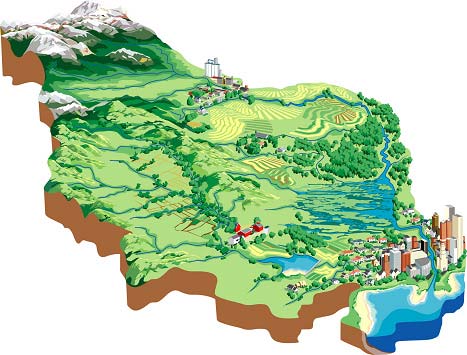
A watershed is an area of land from which all the water drains to the same location, such as a stream, pond, lake, river, wetland, or estuary (see figure below). A watershed can be large, like the Colorado River drainage basin, or very small, such as all the water that drains to a small farm pond. Large watersheds are often called basins and contain many small watersheds.

Watersheds can transport non-point source pollution. Non-point source pollution is associated with rainfall and snowmelt moving over or through the ground, carrying natural and human made pollutants into water sources. Examples of non-point source pollutants are fertilizers, pesticides, sediment, gas, and oil. Pollutants accumulate in watersheds as a result of various human and natural activities. These pollutants, while sometimes inevitable, drastically alter the state of the ecosystem. If we can determine the type of pollutant and its cause, then we can classify the source of the pollutant and take preventative measures to reduce any further contamination.
The table below outlines some examples of land uses and their potential problems.
See Appendix D (pdf) for pictures of land use activities.
| Land Use | Activities | Potential Pollution Problems |
| Agriculture | tillage, cultivation, pest control, fertilization, animal waste | sediment, nitrate, ammonia, phosphate, pesticides, bacteria |
| Construction | land clearing and grading | sediment |
| Forestry | timber harvesting, road construction, fire control, weed control | sediment, pesticides, gas and oil |
| Land Disposal | septic system, land fills | bacteria, nitrate, phosphate, gas and oil, toxic waste, hazardous materials |
| Recreation | ATV's, boating, hiking, camping, fishing | sediment, gas and oil, garbage |
| Roads | clearing trees, soil compaction, dirt excavation | sediment, gas and oil |
| Surface Mining | dirt, gravel, and mineral excavation | sediment, heavy metals, acid drainage, nutrient |
| Urban Storm Runoff | lack of automobile maintenance, lawn and garden care, painting | oil, gas, antifreeze, nutrients, pesticides, paints |
Instructional Procedures
PROCEDURE:
- Divide the candy into the sandwich bags (you may want to manipulate the bags so that the assortment of candy represents a particular land use area by adding more of a certain type of pollutant, rather than relying on a random mix). You may either have one bag per student or one bag per group of students. You should have about 30 pieces of candy per bag. Each bag represents a water sample from a watershed.
- Ask the class to define the word pollutant. Tell them that each color of skittles represents a different kind of pollutant. You can use the visual aids provided in Appendix D to hang up in the classroom.
PURPLE = Sediment
RED = Pesticides
GREEN = Fertilizers
YELLOW = Oil and Gas
ORANGE = Toxic WasteDiscuss each of these pollutants with the students. Ask them where they come from, what they are used for, how they can be beneficial, and how they may be harmful. Refer to the Land Use Chart on the previous page for more information. Discuss what land-use means, and what kind of land use may cause the different kinds of pollution.
- Distribute the graph paper to each student or group. Tell the students that they will be drawing a bar graph to show the number of pollutants found in their "water sample." Show them the sample graph provided. Have the students label the x-axis with the pollutant types and the y-axis with the amount of pollutants.
- Give each group a "water sample." Tell the students to separate and count the number of each pollutant and graph them on the paper. Remind the students that they cannot eat the skittles until they are finished with their graph!
- Ask the students to try and determine what land use activities are occurring in their watershed according to the "water sample." For example, a water sample from an area with a lot of agricultural use may have more sediment, fertilizer, and pesticides. Refer to the Land Use Chart on the previous page for more information.
- Discuss how each water sample is different. While some samples might contain an abundance of one type of pollution, almost all types of pollutants can be found in every sample (even if they are small amounts). Discuss strategies to reduce pollution. How can the students do this on a large scale (in their community) or small scale (in their own home)?
In the community:
- Encourage friends and neighbors to recycle
- Plan a science fair project about water quality and reducing pollution
- Talk to friends and neighbors about what they have learned
- Pick up trash in your neighborhood
In the home
- Encourage parents to fix leaky cars
- Talk to parents about using less fertilizers and pesticides
- Recycle items at home
- Do not dump oil, gas, or other pollutants in the storm drains
Bibliography
This lesson plan was developed by the Utah State University Water Quality Extension.
Updated: 02/22/2022


 UTAH EDUCATION NETWORK

 Justin
 Braxton
 Dani
Dani Kayla
Kayla Katie
Katie Matthew
 Rob
Rob Val
Val
