CAPITOL REEF NATIONAL PARK
Capitol Reef National Park
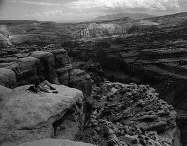
Called by some Native Americans the "Sleeping Rainbow," Capitol Reef National Park takes its name from a segment of the Waterpocket Fold, which, with its many domes of white Navajo sandstone over red Wingate sandstone cliffs, resembles the domes of the U.S. and other capitol buildings. The Waterpocket Fold is a north-south upthrust ridge of slickrock nearly unbroken in the one hundred miles of its length from Thousand Lake Mountain to Lake Powell.
Before the fourteenth century, the area was occupied by prehistoric people known as the Fremont Indians, who scratched petroglyphs and painted pictographs on rock walls of the land near trails and watercourses.
In 1878 Franklin D. Richards, a Mormon settler, established Fruita in Wayne County where park headquarters is now located. Other pioneers tried to establish small communities along the Fremont River. Ephraim P. Pectol of Torrey thought of the "Wayne Wonderland" as a candidate for national or state park status in 1910. Joseph H. Hickman, a member of the Utah state legislature convinced his colleagues to set aside 160 acres as a park. In 1933 Pectol was elected to the legislature and convinced it to memorialize Congress to accept Wayne Wonderland as part of the national park system. Capitol Reef National Monument was the result--established by presidential proclamation in 1937. Those most responsible for its establishment include E. P. Pectol, J. E. Broaddus, a Salt Lake writer, and Dr. A. L. Inglesby of Torrey. After national attention was drawn to the Canyonlands area by the creation of Lake Powell, the monument was expanded to include most of the Waterpocket Fold, and in 1971 the natural wonder was declared a park in the national park system.
The park's Central district includes the original Monument and the road that follows along the river between Fruita and Cainsville. This route along State Highway 24 features wonderful views of colored and eroded rock. The North district is primarily Cathedral Valley, which consists of cliffs and buttes of awesome size and beauty that resemble the shapes of huge gothic buildings. The South district is the long spine of Waterpocket Fold. As a barrier to travelers this spine marks a drift line on the east flank of the plateaus drained by the Colorado River.
Disclaimer: Information on this site was converted from a hard cover book published by University of Utah Press in 1994. Any errors should be directed towards the University of Utah Press.
The Book - Utah History Encyclopedia
Original book edited by:
Allen Kent Powell
Originally published by:
University of Utah Press
J. Willard Marriott Library
295 South 1500 East, Suite 5400
Salt Lake City, Utah 84112
![]() Contact us
Contact us![]() 800-621-2736
800-621-2736
The Website - Utah History Encyclopedia
Website maintained by:
Utah Education Network - UEN
101 South Wasatch Drive
Salt Lake City, Utah 84112
![]() Contact us
Contact us![]() 800-866-5852
800-866-5852
![]() Terms of Use
Terms of Use
![]() Web Accessibility
Web Accessibility