JUAB COUNTY
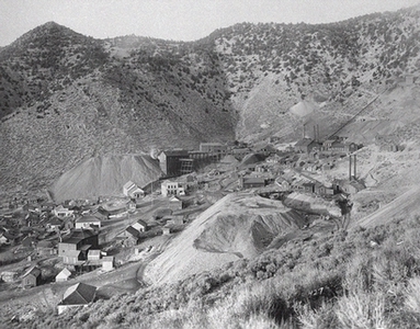
Mammoth Mine, Juab County, 1905
Area: 3,412 square miles;
Population: 5,817 (in 1990);
County seat: Nephi;
Origin of county name: from the Ute word meaning flat or level plain;
Principal cities/towns: Nephi (3,515), Mona (584), Eureka (562), Levan (416);
Economy: agriculture, manufacturing, mining, recreation;
Points of interest: Historic Tintic Mining District, Little Sahara Recreation Area, Old Pony Express and Stage Route, Yuba Reservoir, Goshute Indian Reservation, Tintic Mining Museum in Eureka, Mount Nebo Wilderness Area, Fish Springs National Wildlife Refuge.
Juab County is a part of the Basin and Range physiographic province. Most of the fertile farming land in the county is located in the Juab Valley near Nephi at the base of Mount Nebo (11,877 feet). The western portion of the county consists of broad, semi-arid valleys and low desert mountains. The Wasatch Mountains are located to the east, and moving west there are the East Tintic Range, West Tintic Range, Thomas Range (Topaz Mountain 7,113 feet), Fish Springs Range, and the southern tip of the Deep Creek Range in the extreme northwest corner of the county.
Archaic and Fremont-Sevier cultural sites have been found in Juab County. Nephi Mounds north of Nephi is one of the most important Fremont agricultural sites in the eastern Great Basin. A portion of the Goshute Indian Reservation is located in the northwest corner of the county.
In 1776 the Dominguez-Escalante expedition crossed the county from north to south at the eastern end, passing near present Nephi. Jedediah Smith traversed the western end of the county in 1826 and via Fish Springs in 1827. In 1843-44 John C. Frémont journeyed through the county's eastern end en route north. Government explorers John W. Gunnison and J.H. Simpson traveled in the area in 1853 and 1859, respectively. Gunnison touched the extreme southeast portion of the county while Simpson pioneered the route later used by the Pony Express and the transcontinental telegraph.
In 1852 the legislative assembly created Juab County, which extended as a narrow strip to what was then the western boundary of Utah Territory (now the western boundary of Nevada). The western portion was removed in 1854 to form part of Summit County, Nevada, and several other changes in Juab's borders have been made over the years.
The first settlement in Juab Valley occurred in 1851 when a group of Mormon settlers arrived near Salt Creek, at present-day Nephi. Their economy was based primarily on agriculture.
From 1860 to 1863 Goshutes attacked an overland mail station at Willow Creek. As a result, the U.S. Army established a camp at Cedar Summit and a cantonment at Fish Springs in 1863.
In 1869 precious metals were discovered in the Tintic region, changing the economic and industrial destiny of Juab County. The towns of Diamond, Silver City, Mammoth, and especially Eureka became the main areas of the Tintic Mining District, which by 1899 was labeled one of the foremost mining districts in the country. From 1870 to 1899 Tintic produced approximately $35,000,000 in mineral wealth. The metals in Tintic consisted of silver, gold, copper, lead, zinc, and some uranium at Topaz Mountain. Mining continued through the 1950s, and even today some mining operations continue on a small scale. In recent years, several small manufacturing firms have helped to diversify Juab's economy.
Recreation at the White Sand Dunes, Little Sahara Recreation Area, has been very popular, attracting tourists and outdoor enthusiasts to the western portion of the county.
Disclaimer: Information on this site was converted from a hard cover book published by University of Utah Press in 1994. Any errors should be directed towards the University of Utah Press.
The Book - Utah History Encyclopedia
Original book edited by:
Allen Kent Powell
Originally published by:
University of Utah Press
J. Willard Marriott Library
295 South 1500 East, Suite 5400
Salt Lake City, Utah 84112
![]() Contact us
Contact us![]() 800-621-2736
800-621-2736
The Website - Utah History Encyclopedia
Website maintained by:
Utah Education Network - UEN
101 South Wasatch Drive
Salt Lake City, Utah 84112
![]() Contact us
Contact us![]() 800-866-5852
800-866-5852
![]() Terms of Use
Terms of Use
![]() Web Accessibility
Web Accessibility