ARCHES NATIONAL PARK
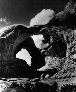
Double Arch
Although there are arches and natural bridges found all over the world, these natural phenomena nowhere are found in such profusion as they are in Arches National Park, located in Grand County, Utah, north of the town of Moab. The Colorado River forms the southern boundary of the park, and the LaSal Mountains are visible from most viewpoints inside the park`s boundaries. The park is situated in the middle of the Colorado Plateau, a vast area of deep canyons and prominent mountain ranges that also includes Canyonlands National Park, Colorado National Monument, Natural Bridges National Monument, and Dinosaur National Monument. The Colorado Plateau is covered with layers of Jurassic-era sandstones; the type most prevalent within the Park is called Entrada Sandstone, a type that lends itself to the arch cutting that gives the park its name.
Arches National Park covers more than 73,000 acres, or about 114 square miles. There are more than 500 arches found inside the park's boundaries, and the possibility exists that even more may be discovered. The concentration of arches within the park is the result of the angular topography, much exposed bare rock, and erosion on a major scale. In such an arid area - annual precipitation is about 8.5 inches per year - it is not surprising that the agent of most erosion is wind and frost.
Flora and fauna in the park and its immediate surrounding area are mainly desert adaptations, except in the canyon bottoms and along the Colorado River, where a riverine or riparian environment is found. Where the landscape is not just bare rock, sage and other low shrubs are common; pinyon and juniper trees are also present. Cottonwoods, willows, and tamarisk predominate in the wetter areas within the park. The largest mammals are bighorn sheep, deer, coyotes, and bobcats; other animals include porcupines, jackrabbits, cottontail rabbits, foxes, mice, and squirrels. Lizards and snakes that have adapted to an arid environment are common, as are birds, both local and migratory, including canyon wrens, ravens, eagles, hawks, and waterfowl along the river.
The first known inhabitants of the area that is now Arches National Park were the archaic groups found throughout the West between 3,000 and 8,000 years ago. (A Folsom projectile point, up to 11,000 years old, was found just west of the Park in 1959.) The first to leave a distinct trace were the Anasazi and Fremont peoples, similar cultures that inhabited the Colorado Plateau from about A.D. 200 to about A.D. 1300. Arches National Park is just outside the Fremont cultural area, so the most common vestiges of ancient society are Anasazi. Within the park are many superb examples of rock art left in hidden canyons by prehistoric artists; dwelling sites and associated artifacts are also found.
The Arches area was inhabited later by two different historic groups of Native Americans, the Ute and the Navajo. Utes lived and hunted throughout the park area, and were responsible for driving out the first white settlers in the area as late as the 1850s. Arches was on the northern fringe of the Navajo lands, and although they passed through the area there is no evidence that Navajos lived within the park area.
The Old Spanish Trail passed through the Spanish Valley, where Moab is now located, and crossed the Colorado River just outside the park boundaries, but it is unlikely that many Spaniards ever ventured into the park. Juan Maria de Rivera, a Spanish trader, passed nearby as early as 1765, and by the 1840s the trail was a well-used route from New Mexico to California. Mountain men were known to travel in the area, but the only one known to have entered the present-day park boundaries was the enigmatic Denis Julien, who left an inscription dated 1844 in the Devil's Garden area of the park. The first Mormon explorers entered the Moab area in 1854, and returned to found the Elk Mountain mission the following year; however, they were quickly driven out of the area by the Utes.
The Mormons returned to help found the town of Moab in the early 1880s, but it wasn't until John Wesley Wolfe, a Civil War veteran, settled on Salt Creek in 1898 that the park had its first white inhabitant. Wolfe and his family lived on their homestead near Delicate Arch until 1910. Other residents of Moab were quick to note the natural wonders of the area, and visits to the arches, canyons, and fins were a regular occurrence by the turn of the century. In 1922, a local miner and prospector named Alexander Ringhoffer visited the area and was so struck by its unique beauty that he contacted officials of the Denver and Rio Grande Railroad, which ran just north of the park, to see if they would be interested in developing the area as a tourist attraction.
Through a roundabout series of events, the National Park Service was informed of the potential of the area for inclusion in the National Park System and, as a result, Arches National Monument was created by President Herbert Hoover in 1929. In 1933 and 1934 the Arches National Monument Scientific Expedition conducted an in-depth reconnaissance of the new monument. The scientists studied the geology, wildlife, plant communities, archeology, and paleontology of the area. The expedition was led by Frank Beckwith, a local newspaper editor and amateur scientist, who was responsible for many of the names of the arches and other features in the park, such as Delicate Arch, Landscape Arch, and Tower Arch. A detailed map of the monument was made, and Beckwith prepared a final report as well as several articles for publication, all of which contributed to the growing popularity of Arches National Monument.
In 1938, like many other western national monuments, Arches was greatly expanded by President Franklin Roosevelt, from its original 4,500 acres to almost 34,000 acres. Despite increasing tourist interest in the area, the first paved road wasn't built into Arches until 1958. Other changes occurred in the 1960s, adding and removing various sections, and it wasn't until 1971 that President Richard Nixon signed the law that changed Arches to a national park and set its size at the present 73,233 acres.
Because of its protected status, Arches National Park was never scarred by the "cat trails" or prospects of the uranium boom of the 1950s, nor by any other mining activities. In 1955-56, a natural gas pipeline was built through the northern sections of the park, leaving a scar that is still visible. Today Moab has become a center of a growing recreation area, with thousands of visitors flocking to the spectacular red-rock cliffs and canyons for mountain biking, river running, cross-country skiing, and other outdoor activities. Arches National Park is one of the most popular destinations among the many national parks and monuments in Utah and nearby states, and thousands of tourists from all over the world visit it each year. The danger today is not from mineral or other types of development, but that Arches, like most other national parks, will be simply "loved to death."