EXPLORATION IN UTAH
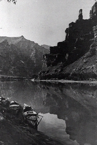
Boats of the Powell expedition, Desolation Canyon
United States government exploration in Utah played a pivotal role in its settlement and economic development of the state. Most, but not all, of the men that carried out the surveys represented the U.S. military as members of the Army Corps of Topographical Engineers. They were the link between the early exploration by Indians and fur trappers and the later civilian scientists and researchers. These explorers not only located and mapped the physical features of this region, but also studied native flora and fauna and made ethnological observations. The majority of the published reports of their findings were well written and interesting to an eastern public eager to learn more about western territories. These narratives were greatly enhanced by illustrations done by artists (and later, photographers) who accompanied the explorers. Most of the surveyors were treated hospitably by Utah settlers who appreciated gaining information about their surroundings at U. S. government expense. The Corps officers also utilized local citizens on many of their projects.
John C. Fremont
There is not a more recognizable name in early government explorations than John Charles Fremont. Although he traversed very little new ground in the west and used former mountain men as guides, his reports and maps provided much valuable information which stimulated westward migration. Fremont's enthusiastic description of the valley of the Great Salt Lake did much to encourage Brigham Young to bring the Mormons to the Great Basin to settle.
Among the few government explorers not educated at West Point, Fremont came west for the first time in 1842, as far as the Wind River Mountains. In May 1843 he mounted a more ambitious, well-equipped exploration that would take him as far as Fort Vancouver in the Oregon country. While en route to the northwest, he detoured south when he reached present-day Soda Springs and went through Cache Valley toward the Great Salt Lake. Following the Bear River to its mouth he was disappointed in not being able to get a good view of the lake. Fremont therefore went south to the Weber River to a point about six miles west of present-day Ogden, proceeded to Little Mountain, and climbed to its summit where he and his men could view the whole expanse of the lake. A few days later, Fremont's party, which included Kit Carson, reached an island (later designated "Fremont Island") from which they made a telescopic survey. They drew a map of the lake from a position on its rocky summit. Just below this point, the group carved what Carson called, "a large cross" on 9 September 1843. Though only seven inches long, it is visible on that rock formation to this day. Fremont also did a brief scientific analysis to determine the lake's salinity.
After completing his trek to Fort Vancouver, Fremont journeyed south along the east slopes of the Sierra Nevadas searching for the mythical Buenaventura River. He confirmed the findings of the early mountain men that there was no channel that drained any of the Utah lakes into the Pacific Ocean. In 1844 Fremont left California and picked up the Old Spanish Trail, returning to the East via Utah Lake, Spanish Fork Canyon, and the Uinta Mountains. He was first to call the area that he had skirted during the year's exploration, "The Great Basin."
In 1845 America's "Pathfinder" spent some more time in the Salt Lake Valley. On this particular trip he discovered the relationship between the Utah and Great Salt Lakes with the connecting Jordan River. Again with Kit Carson, he paid a visit to the large island which he named for its abundance of antelope. When he left the lake, he headed west across the Great Salt Lake Desert toward California, following a central route between those taken earlier by Jedediah Smith in 1827 and by Joseph Walker in 1833. Fremont's course would become a portion of the later Hastings Cut-off. He gave names to Pilot Peak and the Humboldt River in Nevada on this trip.
Fremont's final excursion through Utah was in 1853. It was a privately financed exploration to find a route for the proposed Pacific railroad. His course was similar to another undertaken earlier that year by Captain John W. Gunnison and was of little consequence to Utah's history compared to his earlier visits. However, it is interesting to note that he undertook this exploration in an effort to ascertain what the route would be like during the winter months. He entered present-day Utah by way of the Colorado River, and by the time he came through Fremont Pass and arrived in Parowan his entire party was suffering from hunger and exposure to the harsh winter conditions, having already lost one of their number in death. The local residents took the survivors into their homes and nursed them back to health before they continued on to California over the Old Spanish Trail.
Howard Stansbury
Howard Stansbury was not a graduate of a Military Academy. He spent several years as a non-military civil engineer; however after extensive survey experience in the East, the Great Lakes and other areas in the Trans-Mississippi West, he was commissioned as a First Lieutenant in 1838 when the Corps of Topographical Engineers was first organized. After service during the Mexican War, Stansbury received orders in early spring of 1849 to make a reconnaissance of the Platte River Trail proceeding west across the Wasatch Mountains to Salt Lake City. Among his various tasks, Stansbury was expected to survey the entire valley of the Great Salt Lake, study the Indian tribes and the Mormons, locate a supply route from the valley settlement north to the emigrant trail and make a study of the natural resources in the area.
When the exploration team arrived at Fort Bridger en route to the Salt Lake area, Stansbury had Lt. John Gunnison take the supply train over the Mormon Trail into the valley. Meanwhile, at the Fort, the Stansbury engaged Jim Bridger to lead a small group of his party to explore the country from Bear River Valley to Ogden's Hole. They emerged from Ogden Canyon onto the Mormon Road along the eastern edge of the Great Salt Lake. He concluded that this would not be a good wagon or railroad route into the valley.
After Stansbury met with Gunnison in Salt Lake Valley, allayed the fears of Brigham Young and the local settlers as to the purpose of his survey, and rested a few days, the captain began the location of a wagon road north to Fort Hall, which he found entirely satisfactory for overland travel. Next, starting from the Fort, Stansbury conducted a reconnaissance of the Great Salt Lake traveling counter-clockwise, reaching as far west as Pilot Peak. His party is credited with being the first to completely circumvent the lake by land.
The exploration team wintered in the Salt Lake Valley and then completed their project the following spring and summer. This was the first time that a complete scientific investigation was made of this portion of the Great Basin. By the time the team left the valley in late August 1850 they had established an astronomical base line six miles in length, and surveyed the Jordan River and the Utah and Great Salt Lakes (with all its islands), mapping their definite boundaries. On his return to the East, Stansbury located a new route crossing present-day Wyoming that saved sixty-one miles by using Cheyenne Pass. This route would later be utilized by the Overland Stage, the Pony Express, and the Union Pacific Railroad.
Stansbury's account of his exploration was the most ambitious scientific report of all those submitted prior to the Pacific Railroad Reports, and it had both popular and scholarly appeal.
John Williams Gunnison
West Point honor graduate John Gunnison was transferred for health reasons to the Corps of Topographical Engineers after serving in the Seminole War in Florida. In 1849 he received orders to serve as assistant to Captain Howard Stansbury as he explored and surveyed the region of the Great Salt Lake.
While left in charge that first fall, Gunnison began surveys on the Jordan River and south to the Utah Lake area. He and his crew laid down the astronomical base line upon which a network of triangles could be constructed, thus enabling them to make an accurate map of the entire valley. They erected fourteen triangulation stations to prepare for the mapping operation. After all work was completed a year later, Gunnison assisted Stansbury in preparing his famous report and he drew the excellent maps which accompanied it.
John Gunnison wrote a book focusing on the history, culture and theology of the Mormons based on information he gleaned during his year's stay in the valley. It was probably the most objective work to that date on the subject and had wide appeal as evidenced by its eight domestic and two foreign editions published prior to 1890.
In the summer of 1853 Captain Gunnison (now a captain) was selected to lead one of four main survey parties sent by Secretary of War Jefferson Davis to find the "most practicable and economical" route for the Pacific railroad. Leaving Fort Leavenworth on 23 June 1853 Gunnison supervised the reconnaissance of the 38th parallel course through Kansas, Colorado and into Utah. Planning to winter once more in the Salt Lake Valley, Gunnison hurried to finish the survey by dividing his party in two to cover more ground. While exploring a portion of the Sevier River and Lake, Gunnison and his group were attacked by the local Pahvant Indians. The captain and six of his men were killed. His assistant, Lt. E.G. Beckwith was left to carry on the work. Prior to Gunnison's death, he and his group had already achieved four main results: the survey of a new military road to Taos, New Mexico; the survey of another southern wagon road to California; a military road which would enable the army to penetrate and command Utah if necessary; and the knowledge that the 38th-parallel route was not a desirable course for the railroad because of the tremendous expenses that would be incurred due to extensive tunneling, bridging and spanning of gullies.
Edward G. Beckwith
When Captain John Gunnison was assigned to lead the expedition for the survey of a Pacific railroad route along the 38th parallel, Lieutenant Edward G. Beckwith of the Third Artillery was appointed the assistant commander of the party. After the tragic massacre of Gunnison and six members of his surveying group, Beckwith took the survivors to Salt Lake City to spend the winter of 1853-54.
Prior to his death, Gunnison came to the conclusion that the 41st (or middle central) route was a desirable railroad location. The following spring, eager to locate the most feasible course, Lt. Beckwith and his party re-explored Stansbury's trails between the Salt Lake Valley and Fort Bridger. He concluded that both the Weber and Timpanogos canyons were acceptable passes through which a railroad could travel connecting the valley and the Laramie plains.
Beckwith previously petitioned the Secretary of War to allow his group to continue the 41st parallel survey west to California. On 21 February 1854 the lieutenant received the authorization he sought. Leaving Salt Lake with his contingent and remnants from John Fremont's party, Beckwith crossed the Great Basin passing Pilot Peak on the Utah-Nevada border. Beyond the Humboldt River he located two suitable passes through the Sierra Nevada Mountains. Beckwith was impressed with this relatively straight route through fertile territory. Also, the existing settled community of Mormons from which help was available for building and maintaining the road. However, because he was not an engineer, the lieutenant failed to include a cost estimate for construction of the route; thus, his recommendations were virtually overlooked when all of the surveys were evaluated by Secretary Davis and his associates. The neglect was also due to Beckwith's lack of experience and reputation. But it is interesting to point out that the first transcontinental railroad did eventually follow his recommended route.
Edward J. Steptoe
Lieutenant Colonel Edward J. Steptoe, although not a member of the Corps, supervised the improvements of the Mormon Corridor road in the Cedar City area. When Utah Territory received a Congressional appropriation of $25,000 for the project, Steptoe had already been assigned to lead a column of reinforcements to California. But because of his experience on previous railroad surveys he was selected in 1854 to carry out this Southern Utah. He began the work amid numerous local requests to locate the road to satisfy various interest groups. Even Brigham Young attempted to get the Colonel to spend the appropriation between Salt Lake City and Parowan, rather than the portion of road for which it was intended. However, using Mormon contractors, Steptoe expended the funds for the most unsatisfactory stretchesbetween Cedar City and the head waters of the Santa Clara River. Although the road was opened for travel the funds were gone before an adequate job could be accomplished.
There were added concerns preventing Steptoe from devoting sufficient attention to road building. His position in the state was made difficult due to suspicions that he intended to replace Brigham Young as territorial governor, and because he was charged with bringing to justice the murderers of John Gunnison and his men. In spite of President Franklin Pierce's wishes, Steptoe had no ambition to become governor and signed a petition favoring Young's reappointment. In addition, his inquiry into the massacre also acquitted the Mormons of any blame.
James Hervey Simpson
From 1849 through 1851 James H. Simpson served the Corps in the American Southwest, particularly in Texas and New Mexico, even sharing in the discovery of Chaco Canyon and the carrying out of archeological investigations. Although he recommended the 32nd parallel as a practicable Pacific railroad route, he correctly guessed that the proposed railroad was twenty years into the future. He remained a conservative "wagon road man."
Simpson was assigned to serve as chief topographical engineer for General Johnston's Army of Utah. In 1858 Simpson was ordered by Johnston to make a reconnaissance of a wagon road connecting Camp Floyd in Cedar Valley with the supply depot at Fort Bridger through Timpanogos Canyon, previously recommended by Stansbury, and already partially improved by the Mormons.
After finishing this task, Simpson was ordered back into the field almost immediately. This time he was going in the opposite direction--to survey the Basin west of the Camp to locate a wagon road to California south of the Humboldt River route. Due to the lateness of the season--October 1858--he only went as far as the Thomas Range. The following May, Simpson led a contingent of forty-four men west through Rush Valley, Skull Valley, and the Salt Lake Desert toward Hastings Pass in the Humboldt Mountains. He realized on this trip that the Great Basin was actually made up of a series of valleys and mountain ranges. Taking a more southwest route through central Nevada his group headed toward Carson Lake. After spending a night at Carson City, the group ended up at Genoa, which had been a Mormon settlement. Simpson then left his command, took a stage to Placerville, and spent a short time in California. He returned to Genoa, and the group began their march back to Camp Floyd began on 24 June 1859. Simpson's party traveled a route forty miles south of their earlier trail. The Captain made his descriptions of the new route available to California emigrants.
Simpson's next orders involved finding a possible wagon road between Camp Floyd and Denver City. After the successful completion of this assignment, which included improving his old route to Fort Bridger, he returned to Fort Leavenworth. The Civil War brought to a close this phase of Simpson's career. In a ten-year period he marched more miles throughout the west than any other topographer.
Joseph Christmas Ives
Joseph C. Ives became well acquainted with the west as he assisted in the 35th-parallel exploration in 1853 for the Pacific railroad study. Ives, a former student at both Yale and West Point, received orders in 1857 to lead one of many military expeditions in connection with the Utah or Mormon War. He was told to travel up the Colorado River and investigate the possibility of moving men and equipment into Utah by way of the Colorado and Virgin Rivers.
After a miserable schooner trip around Baja California, Lieutenant Ives arrived at the mouth of the Colorado to begin building a steam boat from parts he and his men brought with them for the journey up the river. It was a tedious experience to labor. By the end of December the group embarked in their crude craft and arrived at Fort Yuma by 9 January 1858 where they were united with two other contingents who had traveled overland from east and west for the purpose of this exploration. Among the newcomers was the famous geologist, John Newberry. After contending with sand bars, curious and sometimes unfriendly Indians, and even a small Mormon spy party directed by Jacob Hamblin, Ives and his men followed the river as far as Cottonwood Valley in present-day Arizona. Leaving the craft in Black Canyon, the group then began the most important aspect of this expedition, which gave Newberry an opportunity to study the eroded plateaus of Northern Arizona and Southern Utah. The members of Ives' party were the first Anglo-Americans known to explore the floor of the Grand Canyon. Upon leaving the canyon, the group headed southeast as far as Bill Williams Mountain. The party then divided, some continuing east and the others, including Ives, veering to the northeast toward the Hopi mesas. After visiting the Hopi villages, Ives concluded his mission when he arrived at Fort Defiance, New Mexico in May 1858.
Clarence King
Within a few years following the Civil War, exploration of the West was moving out of the military realm into the civilian. Two reasons for this were the creation of curriculum by institutions of higher education besides West Point for study in the sciences and engineering, and a new policy allowing such scholars to take part in field studies led by officer-explorers.
Among the first of these was Clarence King, who was educated at Yale University Sheffield Scientific School. King received practical experience as a participant in California's state geological survey. In 1866 King conceived of the idea of a federally funded geological study of the structure and mineral deposits within a 100-mile-wide strip along the Union Pacific-Central Pacific railroads from the Sierras of California to the front range of the Rockies in Southern Wyoming. At age twenty-five, King was able to secure congressional funding for this project under the sponsorship of the Corps. He had a free hand in how he conducted his survey and in choosing his personnel. King's goals were to do a complete survey of land forms in the region, produce more accurate maps, and examine the feasibility for economic development (especially that connected with mining) along the whole route. His first base camp was at Glendale near present-day Reno, Nevada and the task began in May 1867. The work during the first season was hampered when many in the exploring party contracted malaria.
During their second season, the King survey pushed across Nevada and by the end of July the party reached as far east as the Salt Lake desert. After exploring areas north of the Great Salt Lake and into Southern Idaho, the whole group met in Salt Lake City in October 1868 to store equipment and livestock prior to heading east for a vacation. During this second season, King recognized that the formation of the Great Basin was made up of two Pliocene-era lake beds. In studying the silver mines of the area he formulated his theory of "zonal parallelism." This phenomena, first recognized by geologist William P. Blake, concerns the incidence of metal deposits occurring in parallel, longitudinal zones that follow the same patterns as the western mountain ranges.
During the 1869 season, King divided his group into three parties as he strove to complete the survey that year. One party followed the Provo River eastward, exploring the canyons of the Duchesne, and then followed the crest of the Uintas. King's crew traveled through Echo Canyon to the Bear River, following it to its headwaters. They discovered rich coal formations east of the Wasatch range in the Green River area. The third party carried out a mapping project of the Great Salt Lake necessitated by its rising nine feet since Stansbury's survey, and adding some 600 square miles to its area. In August, King returned to Salt Lake City where he sold his surplus equipment at an auction. By the end of November 1869, King met all of his parties in Argenta, Nevada, to close the season and the survey.
Ultimately, after additional important field work, Clarence King would become director of the U.S. Geological Surveys in 1879; which was a consolidation of the western surveys and ended army exploration in the West.
John Wesley Powell
John Wesley Powell developed an interest in the natural sciences as a young boy. After a continuing but intermittent education, losing an arm as he served with distinction in the Union Army during the Civil War, and becoming a professor of natural history, Powell turned his scientific attention to the American West. Although a former military man, he was one of the few government explorers not affiliated with the Corps of Engineers. He made preliminary visits to the Rockies and did land studies of the Colorado River before he began the exploration that would assure his place in history. He launched his famous voyage at Green River, Wyoming in 1869. Before his party of ten men and four boats floated as far as Uinta Valley to restock at the White Rocks Indian Agency on 6 July, they had already lost one boat in the treacherous canyon rapids. When Powell finished his trip down the Green and Colorado Rivers to the mouth of the Virgin River, he would lose another vessel and three of his men--killed by some Shivwits Indians who mistook them for troublesome prospectors. Many feared that the whole party had perished because for almost two months they were not seen by white men on their perilous journey through Desolation, Cataract, Glen, Marble and Grand Canyons. Powell's party became the first to accomplish this journey.
Two years later, this time with a sizable appropriation from Congress to map and explore the Colorado Plateau region, Powell repeated his river voyage as far as Lee's Ferry. This time he left the river to set up headquarters in Kanab, Utah. A year later, in August 1872, Powell's party again embarked (this time on a much higher Colorado River) but officially ended the second river expedition after passing through the dangerous Marble Canyon in Northern Arizona. While he continued his study of the plateau, Powell gave more place names to this region that anyone else except the Mormons. His publications, Exploration of the Colorado River (1875), Geology of the Uinta Mountains (1876), and Report on the Lands of the Arid Regions of the United States With a More Detailed Account of the Land of Utah (1878), provided the necessary scientific information about the Colorado Plateau, particularly its geology and physical boundaries.
As a result of his studies in the west, long before most others, Powell preached the gospel of the rational use of natural resources. He came to realize how the efficient utilization of water through irrigation and a different method of land distribution were critical to survival and prosperity in this region, a fact little understood by easterners.
Powell had also gained the political savvy requisite to promote his causes. He became director of the U.S. Bureau of Ethnology from 1879 until his death in 1902, headed the U.S. Geological Survey from 1881 to 1892, and was director of the National Irrigation Survey. This last organization promoted measures that truly anticipated twentieth century reclamation projects.
Macomb, Hayden and Wheeler
There were some government surveyors, including Clarence Dutton, whose High Plateaus of Utah and Teritiary History of the Grand Canyon District provided valuable information about the geology of the state, as well as others, whose explorations barely touched present-day Utah and whose impact on its history was limited. One of these was Captain John N. Macomb of the Corps. In 1859 an effort was made to find additional supply routes into the Great Basin. Macomb led his team, which included geologist John Newberry, northwest out of Santa Fe, New Mexico, toward the junction of the Grand and Green Rivers. This was the first formal reconnaissance of the San Juan country. Although they were unable to reach their destination and found that no such supply route was possible, the group gained considerable knowledge regarding the geography and geology of that area.
Another of these government explorers whose work had little effect on Utah was Ferdinand Vandiver Hayden. After establishing a reputation in the study of fossil stratigraphy, he carried out western surveys for the Interior Department in direct competition with the Corps. The exploration that brought fame to Hayden was his Yellowstone expedition which was organized in, and left from, Ogden, Utah on 11 June 1871. Also, Hayden"s thorough study of neighboring Colorado south of King's Fortieth-Parallel Surveys had some relevance to Utah as a result of contributions to current knowledge of the state's eastern boundary. Because noted photographer, William H. Jackson was a part of his exploration team, Hayden's reports received greater popular attention and enhanced public appreciation of the scientist/explorer in the West.
The third in this category was Lieutenant George M. Wheeler. As a West Point trained engineer, he represented the Army's last frantic efforts to dominate peace-time western exploration. In 1869 he "instrumentally explored" the area south of King's survey which included a tedious, grueling reconnaissance of Southeastern Nevada and Southwestern Utah. In the process he was the first since the mountain men to make a north-south crossing of the entire Great Basin. Throughout the 1870s he was in control of all geographical activity in the far West.