THE HENRY MOUNTAINS
Henry Mountains
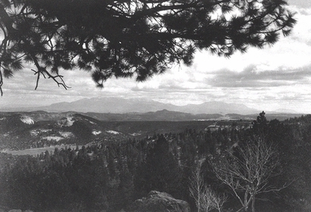
The Henry Mountains of southeastern Utah were one of the last-surveyed and last-named mountain ranges in the lower forty-eight United States. The Henrys are located in the middle of the Colorado Plateau, a sea of sandstone cut by deep canyons. The surrounding country for miles is arid and supports little vegetation; the very ruggedness of their setting left the Henry Mountains isolated and unknown until after the Civil War. Even today the Henrys and the surrounding regions remain isolated and sparsely settled. Ironically, however, among geologists the Henrys are known world-wide because of a classic study of their geology done during the 1870s.
The Henry Mountains are about sixty miles long by about twenty miles wide, and are located in Garfield County, Utah. The nearest settlement is the town of Hanksville to the north. The range is bounded on the east and south by the Colorado River and its tributary, the Dirty Devil River; on the west by the Waterpocket Fold; and on the north by the San Rafael Swell. The vertical relief between the Henrys and the surrounding plateau regions ranges from 6,000 to 8,000 feet. From north to south the highest peaks of the Henrys are as follows: Mount Ellen (the northernmost and also the highest peak), having an elevation of 11,506 feet above sea level; Mount Pennell, with an elevation of 11,371 feet; Mount Hillers, 10,723 feet; Mount Holmes, 7,930 feet; and Mount Ellsworth, at 8,235 feet. The latter two peaks are separated from the main range by a valley, and are sometimes referred to as the Little Rockies because of their rugged appearance. All of these names were given to the peaks by U.S. government surveying parties in the 1870s.
Vegetation zones in the Henrys range from Alpine, along the summit ridges of Mount Ellen, to Warm Desert Shrub at the base of the mountains. Predominant plants are Ponderosa pines, found on the slopes, and pinyon pine, juniper, and gambel oak, rabbitbrush, and greasewood. On the lower elevations sage, dogweed, ephedra, yuccas, and cactus predominate. The vegetation of the Henrys has been drastically affected by overgrazing.
Wildlife on the Henrys is not abundant, due to the arid nature of the surrounding lands. Reptiles are the most common form of vertebrate wildlife, with many different forms and species present, including rattlesnakes. Various species of birds including sage grouse, ravens, hawks and other predators along with other smaller birds inhabit the Henrys. Deer are the largest native mammals, but rabbits and many types of rodents can also be found, as can their predators--coyotes, foxes, bobcats, and an occasional mountain lion. Most predators, however, have been killed off by ranchers. Porcupines and beaver are also present, the latter along the mountain streams. Other species of large mammals have been introduced, either purposely or by accident, with mixed results. Elk and bighorn sheep were introduced (reintroduced, in the latter case) but neither species thrived and today there are no elk in the Henrys. Feral burros, goats, and horses can also be found in the region.
The one successful introduction of a non-native species occurred in 1941 when eighteen buffalo were released north of the mountains. The following year another five bulls were added, and the herd has thrived up to the present. Today they mostly live on the western slopes of the Henrys. During the summer they stay in the higher, cooler elevations, while in the winter they move to Swapp Mesa and Tarantula Mesa west of Mount Pennell. The Utah Department of Wildlife Resources maintains the herd at about 200 individuals. The first buffalo hunt in the Henrys was held in 1950, and a hunt has been held almost every year since 1960.
By the time John Wesley Powell made his pioneering voyage down the Colorado River in 1869, most of the United States was surveyed and mapped. The region around the Henrys, however, remained a blank spot on contemporary maps. Even the peripatetic Spanish explorers failed to leave a lasting name for this range, although it is likely that they were the first whites to notice the mountains from a view point west or south of the Spanish Trail. Neither did the next white men to enter the area, including the French-Canadian trapper Denis Julien; his only known writings are enigmatic inscriptions left in Glen Canyon area of the Colorado River. Jacob Hamblin, the Mormon missionary to the many tribes in the area, surely noticed the Henrys as he traveled back and forth across Glen Canyon in the 1850s, but he too failed to name the mountains. Native American names for the range are not recorded.
John Wesley Powell made note of the range on his 1869 voyage, and called them the Unknown Mountains. When he returned in 1871, he named them the Henry Mountains after Joseph Henry, a close friend who was secretary of the Smithsonian Institution. In 1875 Powell assigned a noted geologist, Grove Karl Gilbert, to study the unique volcanic features of the Henrys, a task which took Gilbert two separate field seasons in 1875 and 1876 to complete. Out of this study came one of the classics of modern geology, the Report on the Geology of the Henry Mountains, published by the U.S. Geological Survey in 1877. In this work Gilbert first identified the Henrys as a laccolithic range, formed by igneous intrusions into the surrounding sedimentary rocks. Gilbert's Report remains a standard work of geology; as Charles B. Hunt, a geologist who studied the Henrys in the 1950s, noted, "The Henry Mountains have been referred to in the geological literature of every language and are one of the localities most widely known to the science. No geologist needs to be introduced to them."
The rigors of the land have precluded any large-scale settlement of the Henrys or the surrounding regions. Evidence of prehistoric inhabitation by both the Fremont and Anasazi cultures is found in the surrounding area, but there is little or no indication of habitation in the mountains themselves. Nor did the Spaniards make any inroads into this isolated area. Although there have never been any permanent settlements in the Henrys themselves, the surrounding region was settled by Mormon pioneers as early as 1882, when Elijah Cutler Behunin moved his family to the present site of Caineville.
The following year Ebenezer Hanks, responding to a mission call to colonize the area, settled north of the Henrys, along the Fremont River, with several other families. A post office was established there in 1885, at which time the town was named Hanksville. By 1890 there were twenty families in the town, and in 1893 LDS Church records showed a population of more than 500 people living in the region. Many other small communities were established along the Fremont River--Giles, Mesa, Clifton, Blue Valley, Notom--but a series of disastrous floods in the 1890s and early 1900s drove most of the settlers away and today only Hanksville survives. South of the mountains were small communities at Hite and Halls Crossing, both being crossings of the Colorado River in Glen Canyon. Today Bullfrog, a recreational community servicing Lake Powell, flourishes on the southern end of the Henrys.
Cattlemen from Colorado moved their herds onto the northern end of the Henrys in the late 1870s, but the practice lasted only a few years before they moved on. By the 1890s, however, many ranches had been established in the Henrys themselves, and a number are still in operation. The first large herds of sheep were introduced into the Henrys around 1900, and by 1925 sheep had largely replaced cattle on the range. Shortly after World War I a large herd of goats was introduced; some of their descendants, since become feral, are said to still survive in the area. The large herds of sheep and cattle badly overgrazed the slopes of the Henrys, and the ranges have not recovered to the present day. Where there are cattle there are cattle rustlers, and the Henrys had their share of outlaws and other shady characters. The Outlaw Trail passed nearby, and one of the most used hideouts was the Robbers Roost country, just east of the Henrys. This area was the haunt of many desperadoes, including the Wild Bunch. Outlaws probably passed through or hid in the Henrys, and certainly hunted there, but most of their activities were elsewhere.
It was the lure of precious metals that brought the largest influx of settlers into the area. Glen Canyon experienced a number of gold rushes beginning in the early 1890s which had an effect on the Henrys. Lumber for the mining camps and for the Stanton Dredge was cut at many places in the mountains, and roads to reach the stands of timber were built up Bull Creek, where a sawmill was also built. Naturally, some of this activity led to other activities in the mountains. In 1890 Jack Sumner, who had been with Powell in 1869, located the Bromide Mine near the summit of Mount Ellen. Prospects seemed good, and by 1893 more than 100 men were reported to be working in the area. A small town called Eagle City was established at Crescent Creek, at the foot of the mountains, with homes, a hotel, two saloons, a dance hall, three stores, and a post office. The Denver and Rio Grande Western Railway made preliminary surveys for a branch line from Green River, Utah, to Eagle City. However, by 1900 the pocket had played out and Eagle City was a ghost town. Other mines were begun on Mount Hillers, and a number of prospects were developed on the eastern slopes of Mount Pennell by Edwin T. Wolverton, beginning around the turn of the century. Wolverton build a stamping mill there in 1921, but none of the mines proved of any worth, and today there is no active gold mining in the Henrys.
Coal fields west of the Henrys were worked intermittently from the time the first was opened in 1888 until about 1945, when the difficulties of getting the coal to markets caused their closure. The only mineral that ever has been mined in large quantities in the Henrys is uranium. Mines were first opened in the decade just before World War I, when radium was found to be useful for medical treatments and luminous paint. Exploration for and production of uranium faltered until after world War II. In the late 1930s and during World War II, small amounts of vanadium (which occurs with uranium and was required for tempering steel) were mined in the Henrys. After the war, with the demand for uranium for nuclear weapons, many other uranium deposits throughout the Henrys were prospected and mined, and some of them are still worked today. South of the Henrys, the small settlement of Ticaboo, with a mill and company town, was built in the late 1970s to process uranium from nearby mines. By the time the town and mill were completed, however, the price of "yellowcake" (processed uranium ore) had dropped and the mill was shut down. Today, rusting machinery, abandoned shafts, and scattered debris are all that survive as relics of the uranium booms of the 1950s.
The conditions of aridity, isolation, and rugged surroundings that have always kept settlement and development in the Henry Mountains to a minimum will no doubt preclude any large-scale influx of people in the immediate future. The landscape is just too harsh, the distances too vast. Lake Powell, which flooded Glen Canyon of the Colorado River south of the mountains, draws a large number of recreationists each year, and some of these who seek solitude and wildness find their way into the Henrys. Some grazing is still allowed in the mountains, and there are still active mining claims, but neither of these uses will likely have much impact on the range in the future. The Henry Mountains will likely remain the way they have been for countless ages, an isolated pocket of wilderness in an ever growing sea of humanity.