

 UTAH EDUCATION NETWORK

 Justin
 Dani
Dani Rob
Rob Val
Val Kayla
Kayla
Utah National Parks
Bryce Canyon National Park

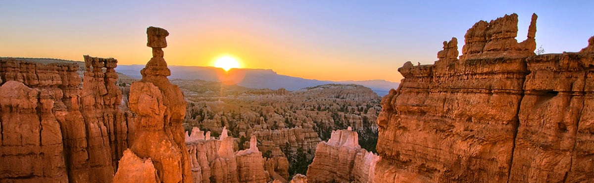
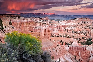 Bryce Canyon National Park contains some of the world's most oddly shaped and beautifully colored rocks. Millions of years of wind, water and ice have formed the rocks into spires, called "hoodoos." It is the uniqueness of the rocks that caused Bryce Canyon to be designated as a national park.
- U.S. National Park Service
- History and Culture
- Nature and Science
- Curriculum Resources For Teachers
- Utah History Encyclopedia
Maps
- NPS Printable Map (pdf)
The full-color map that's handed out at the entrance station. Includes trails, roads and points of interest.
- Google Map
Browser based map of the park. Click and drag maps to view adjacent sections immediately. View satellite images of the park that you can zoom and pan.
- Bryce Ampitheater Region Map
nps.gov detailed map of the Ampitheater Region.
Photos
- Utah Collections
A collection of pictures, videos and documents related to the park. - nps.gov
US National Park Service photo gallery of Bryce Canyon.
Sights to See
| Average Temperatures | ||
|---|---|---|
| January | 39°F | 9°F |
| February | 41°F | 13°F |
| March | 46°F | 17°F |
| April | 56°F | 25°F |
| May | 66°F | 31°F |
| June | 76°F | 38°F |
| July | 83°F | 47°F |
| August | 80°F | 45°F |
| September | 74°F | 37°F |
| October | 63°F | 29°F |
| November | 51°F | 19°F |
| December | 42°F | 11°F |
- Agua Canyon - two prominent hoodoos reside in Agua Canyon. On the left, is the taller of the two towers, "The Hunter." To the right is a hoodoo commonly referred to as the "Rabbit" or alternatively the "Backpacker."
- Bryce Point - one of the most scenic vistas of the full amphitheater.
- Fairyland Canyon - see hoodoos at an "eye-to-eye" level.
- Farview Point - views of famous landmarks that make up the Grand Staircase.
- Inspiration Point - The viewpoint at Inspiration Point consists of three levels that provide varied spectacular perspectives of the main amphitheater.
- Mossy Cave - a wide, mossy overhang in the Claron limestone, kept moist by water dripping from the ceiling. This freezes in winter, and the large ice pillars beneath do not fully melt until midsummer.
- Natural Bridge - This arch poses a stark contrast to the dark green of the Ponderosa forest that peeks through the arch from the canyon below.
- Paria View - Looks across hoodoos and an amphitheater carved by Yellow Creek. The Aquarius Plateau and Paria River Valley are in the background.
- Ponderosa Canyon - is so named because of the huge Ponderosa Pines on the canyon floor. Some of these trees measure more than 5 ft. in diameter and exceed heights of 150 ft.
- Rainbow & Yovimpa - From Rainbow Point the entirety of the park stretches out before you back to the north. From Yovimpa Point you can get a good look at the sequence of rock layers called the Grand Staircase.
- Sunrise Point - The view to the northeast from Sunrise Point captures Boat Mesa and the Sinking Ship, set against the stark Pink Cliffs of the Aquarius Plateau.
- Sunset Point - offers vistas of some of the most famous and breathtaking of Bryce Canyon's hoodoos.
- Swamp Canyon - appears relatively small and sheltered from the overlook, bounded on both sides by fins and hoodoos.
Park Activities
Biking
- Trails.Com: Mountain Biking
Bryce Canyon National Park Area Mountain Biking - Search for Trails by Map.
Camping
- nps.gov
US National Park Service information about camping in Bryce Canyon. - nps.gov - Backcountry Camping
Information about camping in the backcountry of Bryce Canyon.
Hiking / Backpacking
- nps.gov
US National Park Service information about hiking in Bryce Canyon. - nps.gov - Backcountry Hiking Brochure (pdf)
Information about backcountry hiking in Bryce Canyon. - Outdoor Eyes
Downloadable GPS waypoints of the hiking trails in the park. -
Trails.com
Bryce Canyon National Park Hiking - Search for Trails by Map.
Horseback Riding
- nps.gov
Private Horse & Mule Riding at Bryce Canyon
Scenic Drives
- AllTrails
Bryce Canyon NP Scenic Drive is a 20.5 mile moderately trafficked point-to-point trail located near Tropic, Utah that offers scenic views and is good for all skill levels.