

 UTAH EDUCATION NETWORK

 Justin
 Dani
Dani Rob
Rob Val
Val Kayla
Kayla
Utah National Parks
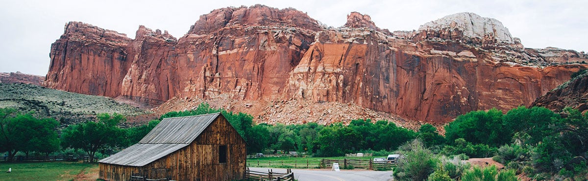
Capitol Reef National Park

General Info & Web sites
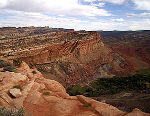 Capitol Reef National Park is known for its Waterpocket Fold. The Fold is a 100-mile stretch of buckled earth characterized by red cliffs, unique spires, and large domes. Despite its unique beauty, Capitol Reef is the least visited of Utah's five national parks.
- U.S. National Park Service
- History and Culture
- Nature and Science
- Curriculum Resources For Teachers
- Utah History Encyclopedia
Maps
- NPS Printable Map
Printable map of Capitol Reef. - Google Map
Browser based map of the park. Click and drag maps to view adjacent sections immediately. View satellite images of the park that you can zoom and pan.
Photos
- Utah Collections
A collection of pictures, videos and documents related to the park. - nps.gov
US National Park Service photo gallery of Capitol Reef.
Sights to See
| Average Temperatures | ||
|---|---|---|
| January | 41°F | 18°F |
| February | 48°F | 24°F |
| March | 56°F | 30°F |
| April | 66°F | 38°F |
| May | 76°F | 47°F |
| June | 87°F | 55°F |
| July | 92°F | 62°F |
| August | 89°F | 61°F |
| September | 81°F | 53°F |
| October | 68°F | 42°F |
| November | 53°F | 30°F |
| December | 42°F | 21°F |
- The Behunin Cabin - On scenic Highway 24 on the south side of the road is the Behunin Cabin. In 1882 Elijah Cutler Behunin and his family built the cabin and stayed a brief time until the rising river washed out their crops.
- Capitol Dome - The white dome of Navajo sandstone resembles the U.S. Capitol building in Washington DC.
- Capitol Gorge - a narrow steep-walled canyon that extends for several miles southwards, and a pleasant foot trail runs along its base and passes some ancient Indian petroglyphs.
- Cathedral Valley - an area of monolithic formations of Entrada and Curtis sandstones, some of which are 500 feet high.
- Chimney Rock - an impressive pinnacle of Moenkopi Shale that rises from the desert.
- The Fruita Schoolhouse - a restored and refurbished historic structure located on Utah Highway 24, .8 miles east of the visitor center.
- The Golden Throne - a dome covered in a gold-colored Navajo Sandstone, which is particularly special because normally the sandstone is creamy white.
- The Goosenecks - the snakelike switchbacks of Sulphur Creek carved into the rock as the Waterpocket Fold slowly lifted
- Hickman Bridge - A large natural stone bridge that spans 133 feet and has an opening of 125 feet high. It takes a short hike to get to, with ancient "Rock Art" and ruins along the way.
- The Historic Gifford Homestead - 1 mile south on the Scenic Drive, is typical of rural Utah farm-houses of the early 1900s and is open during the summer season.
- Scenic Drive - a 20-mile round-trip drive that will take you past the Ripple Rock Nature Center and many of the park's features.
- Waterpocket Fold - the main feature of the park, is a 100-mile-long fold in the earth's surface.
Park Activities
Biking
- nps.gov
National Park Service information about biking in the park. - Trails.Com: Mountain Biking
Capitol Reef National Park Area Mountain Biking - Search for Trails by Map.
Camping
- nps.gov
US National Park Service information about camping in Capitol Reef. - Recreation.gov
Camping options and reservations for camping in Capitol Reef National Park
Climbing
- nps.gov
US National Park Service information about climbing in Capitol Reef. - Mountain Project
Find climbing areas and routes in Capitol Reef National Park and discover photos, user reviews, and detailed route info like climbing type and grade.
Hiking / Backpacking
- nps.gov
US National Park Service information about hiking in Capitol Reef. -
Trails.com
Capitol Reef National Park Hiking - Search for Trails by Map.
Horseback Riding
- nps.gov
Private Horse & Mule Riding at Capitol Reef
Scenic Drives
- nps.gov
Capitol Reef National Park - Road Tours - Visit Utah
Nonstop Knockout Scenery: Seeing the best of the Capitol Reef National Park area by car.