Utah National Parks

Arches National Park
General Info & Web sites
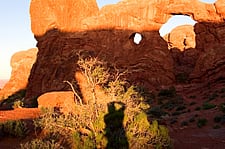
 Arches National Park is known for its natural sandstone arches and unique formations, carved by the powerful forces of water, frost and wind. Visitors to the park can see over 2,000 arches, including the world-famous Delicate Arch. Arches National Park is located near Moab, Utah in red-rock country, overlooking the gorge of the Colorado River.
- U.S. National Park Service
- Student Guide to Arches (pdf)
- History and Culture
- Nature and Science
- Curriculum Resources For Teachers
- Utah History Encyclopedia
Maps
- NPS Printable Map
The full-color map that's handed out at the entrance station. Includes trails, roads and points of interest.
- Google Map
Browser based map of the park. Click and drag maps to view adjacent sections immediately. View satellite images of the park that you can zoom and pan.
- Arches National Park Map (jpg)
Created by Justin Morris
Photos

- Utah Collections
A collection of pictures, videos and documents related to the park. - Arches Slide Show
Photo Gallery of Arches National Park by Moab Utah. - nps.gov
US National Park Service photo gallery of Arches.
Sights to See
| Average Temperatures | ||
|---|---|---|
| January | 44°F | 22°F |
| February | 52°F | 28°F |
| March | 64°F | 35°F |
| April | 71°F | 42°F |
| May | 82°F | 51°F |
| June | 93°F | 60°F |
| July | 100°F | 67°F |
| August | 97°F | 66°F |
| September | 88°F | 55°F |
| October | 74°F | 42°F |
| November | 56°F | 33°F |
| December | 45°F | 23°F |
- Balanced Rock - a large balancing rock, the size of three school buses
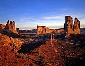
- Courthouse Towers - a collection of tall stone columns
- Dark Angel - a free-standing column of dark stone at the end of the Devil's Garden trail
- Delicate Arch - a lone-standing arch which has become a symbol of Utah
- Devil's Garden - with many arches and columns scattered along a ridge
- Double Arch - two arches that share a common end
- Fiery Furnace - an area of maze-like narrow passages and tall rock columns (see biblical reference Fiery Furnace)
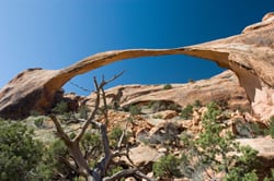
- Landscape Arch - a very thin, very long arch over 300 feet (100 m); the largest in the park
- Petrified Dunes - petrified remnants of sand dunes blown from the ancient lakes that covered the area.
- nps.gov
US National Park Service information about biking in Arches. - Trails.Com: Mountain Biking
Arches National Park Area Mountain Biking - Search for Trails by Map.
- nps.gov
US National Park Service information about camping in Arches.
- nps.gov
US National Park Service information about climbing in Arches. - Mountain Project
Rock climbing in Arches National Park, including routes, reglations and closures.
- Hiking in the Moab Area
Hiking information in and around Arches National Park. - nps.gov
US National Park Service information about hiking in Arches. - Outdoor Eyes
Downloadable GPS waypoints of the hiking trails in the park. - Trails.com
Arches National Park Hiking - Search for Trails by Map.
- nps.gov
US National Park Service information about driving through Arches. - Scenic Drives in the Moab Area
Moab area auto tours that will take you through some of the most spectacular scenery in Utah. - Arches National Park Driving Tour
Arches National Park Driving Tour is a 28.3 mile heavily trafficked point-to-point trail located near Moab, Utah that features a waterfall and is good for all skill levels.
World's Biggest Arch
Arch in Utah national park called world's biggest 
By Mike Stark
SALT LAKE CITY (AP) — Utah state geologists and a group of intrepid volunteers say they've finally answered a nagging geological question: What's the longest natural arch in the world?
The answer, they say, is Landscape Arch in Arches National Park in southeastern Utah.
Of course, it all depends on how you measure it. But members of the all-volunteer Natural Arch and Bridge Society spent years developing a standardized measurement that looks at the widest horizontal opening in each arch — not the arch itself.
Using that yardstick, they found that Landscape Arch spanned about 290 feet. Kolob Arch in Zion National Park came in at 3 feet shorter.
Grant Willis, a geological mapper at the Utah Geological Survey, said the group's survey — which ranks the top 10 arches in the world — finally offers definitive answers about the arches with the longest spans.


 UTAH EDUCATION NETWORK

 Justin
 Dani
Dani Rob
Rob Val
Val Kayla
Kayla

